No higher resolution available.
Palestine_Partition_Commission_Plan_B,_1938.jpg (229 × 568 pixels, file size: 42 KB, MIME type: image/jpeg)
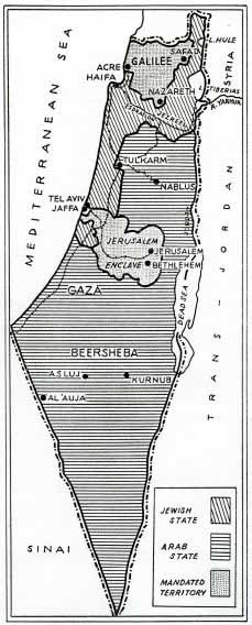
A map from the Palestine Partition Commission in 1938 showing the Palestine Partition plan that laid out the territory of the Jewish state, the Arab State and Mandated territory
File history
Click on a date/time to view the file as it appeared at that time.
| Date/Time | Thumbnail | Dimensions | User | Comment | |
|---|---|---|---|---|---|
| current | 01:55, 13 November 2023 | 229 × 568 (42 KB) | Cassette (talk | contribs) |
You cannot overwrite this file.
File usage
The following page uses this file: