(minor changes) Tag: Visual edit |
(began working on partition plan section) Tag: Visual edit |
||
| Line 37: | Line 37: | ||
Lastly, these strikes resulted in the further deterioration of Palestinian resistance, which gave the Zionists easy access to the Palestinian rural areas, intensifying their ethnic cleansing campaigns. | Lastly, these strikes resulted in the further deterioration of Palestinian resistance, which gave the Zionists easy access to the Palestinian rural areas, intensifying their ethnic cleansing campaigns. | ||
=== Partition plan (UN Resolution 181) === | |||
Unable to resolve the conflict between Palestinians and settlers, Britain withdrew from Palestine in February 1947 and transferred the matter to the UN, which in turn entrusted it to [[UNSCOP]]. | |||
While UNSCOP did deliberate about the possibility of a democratic one-state solution, whose future would be determined through democratic organs, they ended up adopting a partition plan which divided Palestine into two states: "Israel", occupying 56% of all Palestinian land and containing the Eastern Galilee, a coastal area (including Haifa, Tel Aviv, and most fertile lowland plains) and most of the Negev, and Palestine, consisting of the remaining territories, except for Jerusalem, which was to be considered ''corpus separatum''.<ref>{{Web citation|author=Alex Winder|newspaper=Palquest|title=UN Partition Plan, 1947|url=https://palquest.palestine-studies.org/sites/default/files/Revisiting_the_UNGA_Partition_Resolution-Walid_Khalidi.pdf|archive-url=https://web.archive.org/web/20240129081137/https://palquest.palestine-studies.org/sites/default/files/Revisiting_the_UNGA_Partition_Resolution-Walid_Khalidi.pdf|archive-date=2024-1-9|retrieved=2024-6-20|quote=The proposed Jewish state covered some 56 percent of Mandate Palestine divided into three barely contiguous parts/areas: the eastern Galilee (including Safad, Tiberias, Baysan, and the Sea of Galilee), a coastal area (about two-thirds of Palestine's coast, including Haifa, Tel Aviv, and the fertile lowland plains), and most of the Negev (excluding Bir al-Sabi' and a strip/area running about half-way down the border with Egypt, but giving access to the Red Sea). Of Mandate Palestine's sixteen districts, nine were allotted to the Jewish state, only one of which had a Jewish majority; the UN-proposed Jewish state as a whole had an Arab “minority” approaching 47 percent.}}</ref> Additionally, it is also worth mentioning that even within the UN-proposed state, settlers owned only 11% of the land and were the minority in every single district, further adding to the absurdity that was this plan.<ref>{{Citation|author=Ilan Pappe|year=2006|title=The Ethnic Cleansing of Palestine|chapter=Chapter 3|section=The Arab and Palestinian Positions|page=34|quote=The injustice was as striking then as it appears now, and yet it was hardly commented on at the time by any of the leading Western newspapers then covering Palestine: the Jews, who owned less than six per cent of the total land area of Palestine and constituted no more than one third of the population, were handed more than half of its overall territory. Within the borders of their UN -proposed state, they owned only eleven per cent of the land, and were the minority in every district|pdf=https://cloudflare-ipfs.com/ipfs/bafykbzacedod4irl7doqf2n5iym5sa2eyrmk6ql2zs7yq7yznvezr26fielzc?filename=Ilan%20Pappe%20-%20The%20Ethnic%20Cleansing%20of%20Palestine-Oneworld%20%282006%29.pdf|publisher=Oneworld|isbn=9781851684670|lg=http://libgen.rs/book/index.php?md5=44F7CEAB3B4EA784451D636BC648D02F}}</ref> | |||
Following this plan, which became known as UN Resolution 181, the [[Arab League]] and the [[Arab Higher Committee]] refused to negotiate any further with UNSCOP, creating a power vacuum later weaponized by the colonizers. | |||
=== Zionist colonization (1948–present) === | === Zionist colonization (1948–present) === | ||
[[File:West Bank.png|thumb|239x239px|Green: Palestinian control<br>Red: Joint control<br>Blue and pink: "Israeli" control]] | |||
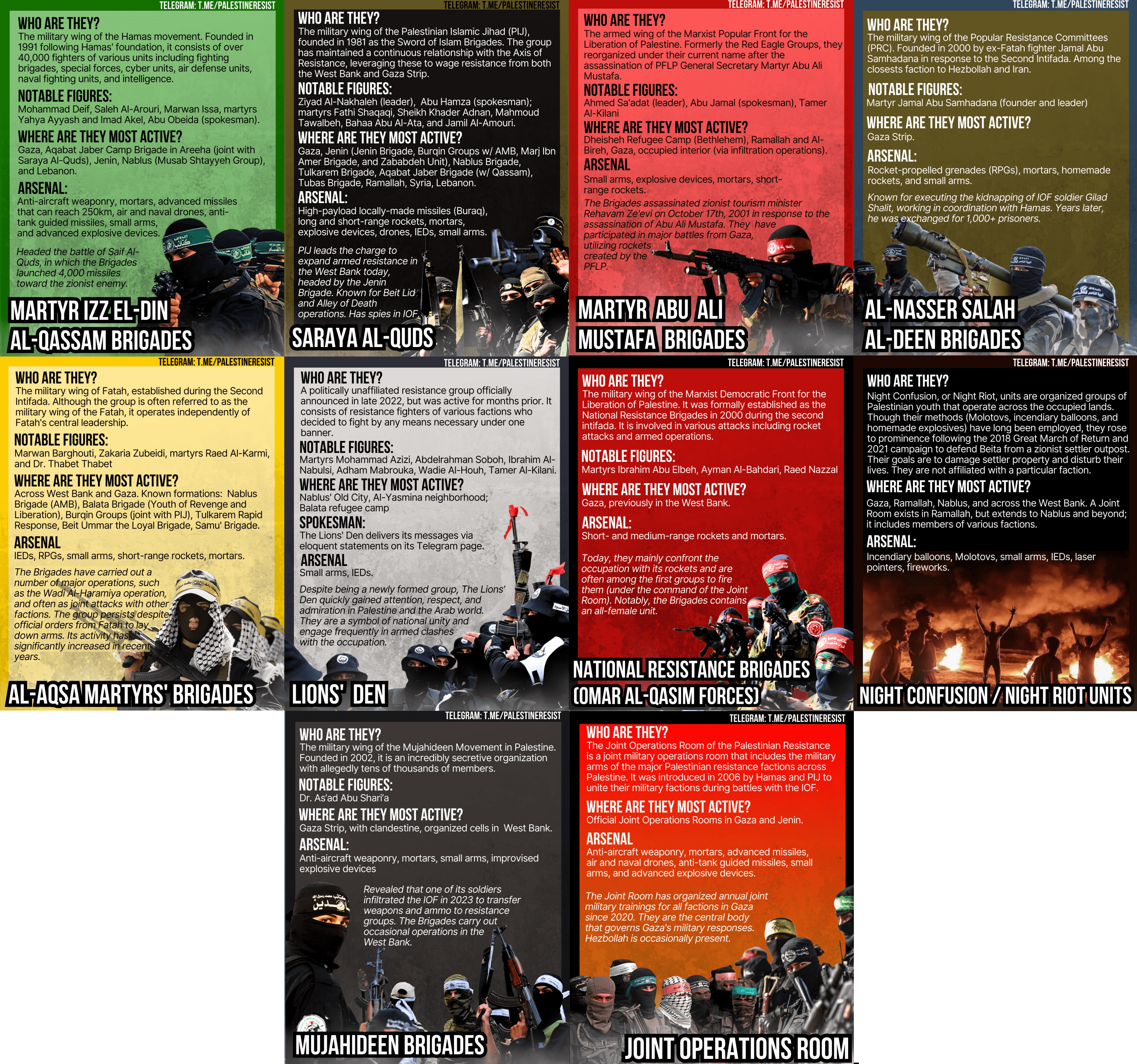
[[File:Palestinian resistance groups.png|thumb|Diagram of ten different Palestinian resistance groups]] | {{Main article|Palestinian genocide}}[[File:Palestinian resistance groups.png|thumb|Diagram of ten different Palestinian resistance groups]] | ||
== Territory == | == Territory == | ||
Revision as of 15:53, 20 June 2024
| State of Palestine دولة فلسطين | |
|---|---|
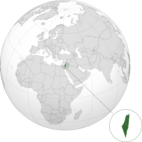 Map of Palestine, including areas occupied by Israel. | |
| Capital (partially occupied by the Zionist Entity) | Jerusalem |
| Capital-in-exile | Ramallah |
| Largest city | Gaza City |
| Official languages | Arabic |
| Leaders | |
• President | Mahmoud Abbas |
• Prime Minister | Mohammad Shtayyeh |
| History | |
• Declaration of Independence | 15 November 1988 |
Palestine, officially the State of Palestine, is an independent state in West Asia that is almost entirely occupied by the Zionist Entity.[1]
History
Medieval history
During the Mamluk Sultanate, the Palestinian city of Jenin was a central station for the postal service between Cairo and Damascus. The Ottoman Empire ruled Palestine for 401 years, starting in the 16th century.[2]
Early Zionist settlement
In the 19th and early 20th centuries, a movement known as Zionism was formed, advocating a homeland for Jewish people in the, then British occupied, land of Palestine. At the same time, the majority Arabic population, who had lived in Palestine for generations, desired independence from the British in the form of an independent Arabic state. In 1917 the British released the Balfour Declaration, which expressed full support to the Zionist movement. The Palestinian people, angered by the British completely ignoring their interests, began protests and rioting against Jewish occupation as early as 1920. These protests were largely led by Amin al-Husseini, the Grand Mufti of Jerusalem.[3]
Arab Revolt (1936–1939)
Starting April 19, 1936, a mass strike against the British instatement of Zionism in the region was formulated. The strike was organized by the Arab Higher Committee, a Palestinian independence movement under the leadership of Amin al-Husseini. This strike eventually led to violent insurgency against British rule in the countryside. The British reacted to these strikes as any imperialist power would; through violent suppression. The British seized and searched property, often without warrants, tortured Palestinian prisoners, and deported Palestinian people from their homeland. There were also many violent encounters between Palestinian resistance, the British army, and Zionist paramilitary groups.
By the time it concluded in September 1939, more than 5,000 Arabs, over 300 Jews and 262 Britons had been killed, and at least 15,000 Arabs were wounded.[4]
Lastly, these strikes resulted in the further deterioration of Palestinian resistance, which gave the Zionists easy access to the Palestinian rural areas, intensifying their ethnic cleansing campaigns.
Partition plan (UN Resolution 181)
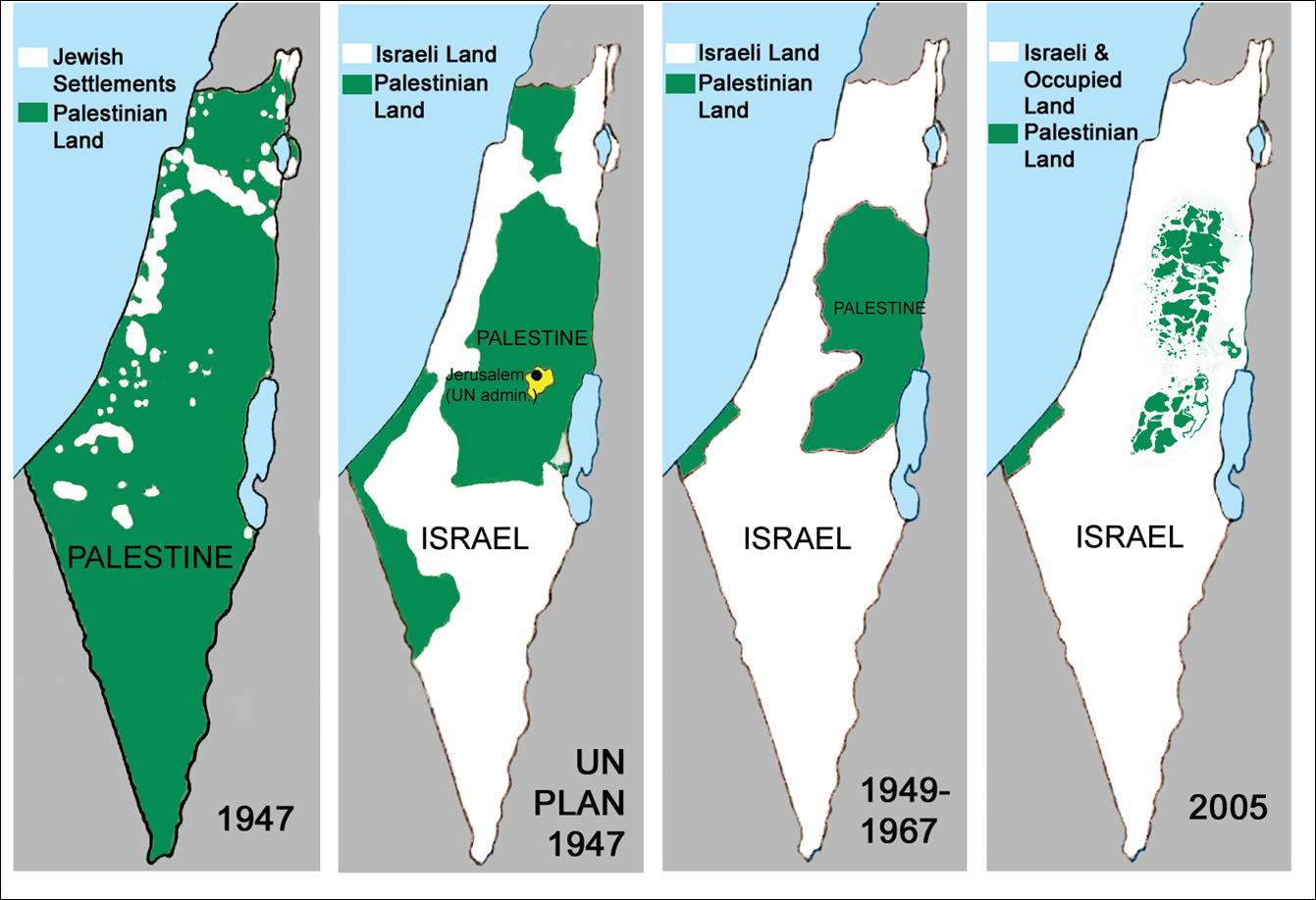
Unable to resolve the conflict between Palestinians and settlers, Britain withdrew from Palestine in February 1947 and transferred the matter to the UN, which in turn entrusted it to UNSCOP.
While UNSCOP did deliberate about the possibility of a democratic one-state solution, whose future would be determined through democratic organs, they ended up adopting a partition plan which divided Palestine into two states: "Israel", occupying 56% of all Palestinian land and containing the Eastern Galilee, a coastal area (including Haifa, Tel Aviv, and most fertile lowland plains) and most of the Negev, and Palestine, consisting of the remaining territories, except for Jerusalem, which was to be considered corpus separatum.[5] Additionally, it is also worth mentioning that even within the UN-proposed state, settlers owned only 11% of the land and were the minority in every single district, further adding to the absurdity that was this plan.[6]
Following this plan, which became known as UN Resolution 181, the Arab League and the Arab Higher Committee refused to negotiate any further with UNSCOP, creating a power vacuum later weaponized by the colonizers.
Zionist colonization (1948–present)
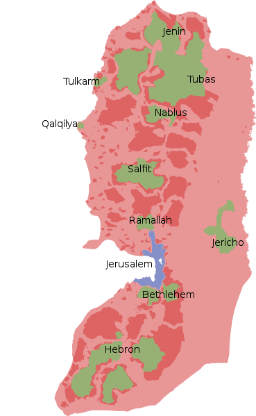
Red: Joint control
Blue and pink: "Israeli" control
See main article: Palestinian genocide
Territory
Before 1948, Palestine consisted of all of the land on the land on the Sinai Peninsula outside of Egypt. In 1948, the area was forcibly partitioned into two states, "Israel" and Palestine. The Zionist Entity was not satisfied with its territory and soon annexed 60% of Palestinian land in the Arab–"Israeli" War.[7] During the Six-Day War in 1967, the Zionist Entity invaded the rest of Palestine and annexed East Jerusalem.[8] Most of the West Bank is now occupied by "Israel".[9]
Further reading
References
- ↑ "An Open Letter to Robert F. Kennedy Jr" (2023-08-11). MintPress News. Archived from the original on 2023-08-12.
- ↑ Miko Peled (2023-08-11). "An Open Letter to Robert F. Kennedy Jr" MintPress News. Archived from the original on 2023-08-12.
- ↑ “The combined impact of Britain's military and diplomatic efforts brought the rebellion to an end in the late summer of 1939. Over the revolt's three years, some 5,000 Palestinians had been killed and nearly 15,000 wounded. The Palestinian leadership had been exiled, assassinated, imprisoned, and made to turn against one another. At the same time, the White Paper—despite its limitations—offered certain concessions to the rebels' demands. Whatever gains Palestinians might have made through the revolt, however, were quickly overtaken by the larger geopolitical processes of World War II , and the combined British-Zionist assault on Palestinian political and social life during the revolt had a long-lasting impact.”
Alex Winder (2024-06-14). "Great Arab Revolt, 1936-1939" Palquest. Archived from the original on January 29th 2024. Retrieved June 14th 2024. - ↑ “The combined impact of Britain's military and diplomatic efforts brought the rebellion to an end in the late summer of 1939. Over the revolt's three years, some 5,000 Palestinians had been killed and nearly 15,000 wounded. The Palestinian leadership had been exiled, assassinated, imprisoned, and made to turn against one another. At the same time, the White Paper—despite its limitations—offered certain concessions to the rebels' demands. Whatever gains Palestinians might have made through the revolt, however, were quickly overtaken by the larger geopolitical processes of World War II , and the combined British-Zionist assault on Palestinian political and social life during the revolt had a long-lasting impact.”
Alex Winder. "Great Arab Revolt, 1936-1939" Palquest. Archived from the original on January 29th 2024. Retrieved June 14th 2024. - ↑ “The proposed Jewish state covered some 56 percent of Mandate Palestine divided into three barely contiguous parts/areas: the eastern Galilee (including Safad, Tiberias, Baysan, and the Sea of Galilee), a coastal area (about two-thirds of Palestine's coast, including Haifa, Tel Aviv, and the fertile lowland plains), and most of the Negev (excluding Bir al-Sabi' and a strip/area running about half-way down the border with Egypt, but giving access to the Red Sea). Of Mandate Palestine's sixteen districts, nine were allotted to the Jewish state, only one of which had a Jewish majority; the UN-proposed Jewish state as a whole had an Arab “minority” approaching 47 percent.”
Alex Winder. "UN Partition Plan, 1947" Palquest. Archived from the original on 2024-1-9. Retrieved 2024-6-20. - ↑ “The injustice was as striking then as it appears now, and yet it was hardly commented on at the time by any of the leading Western newspapers then covering Palestine: the Jews, who owned less than six per cent of the total land area of Palestine and constituted no more than one third of the population, were handed more than half of its overall territory. Within the borders of their UN -proposed state, they owned only eleven per cent of the land, and were the minority in every district”
Ilan Pappe (2006). The Ethnic Cleansing of Palestine: 'Chapter 3; The Arab and Palestinian Positions' (p. 34). [PDF] Oneworld. ISBN 9781851684670 [LG] - ↑ Area of Jurisdiction and Powers Ordinance (1948) (1948) (p. 57). israellawresourcecenter.org.
- ↑ Milestones: 1961–1968 (2018). Office of the Historian.
- ↑ "Applicability of the Geneva Convention relative to the Protection of Civilian Persons in Time of War, of 12 August 1949, to the Occupied Palestinian Territory, including Jerusalem, and the other occupied Arab territories" (2003-12-17). United Nations. Archived from the original on 2007-06-03. Retrieved 2022-01-03.
