More languages
More actions
(Created page with "{{Infobox settlement|native_name=钓鱼岛 diào yú dǎo|name=Diaoyu Islands|population_estimate=No residents|area_land_km2=3.91|image_map=钓鱼岛地理位置.jpg}} '''Diaoyu Islands(Chinese: 钓鱼岛)''' is a disputed area between China and Japan. == History == The archipelago was first recorded in 1403 in the Chinese book "shùn fēng xiāng sòng(顺风相送)". In 1561 and 1605, the Ming Dynasty's naval defense maps included the islands within the boun...") Tag: Visual edit |
General-KJ (talk | contribs) m (Minor changes) Tag: Visual edit |
||
| Line 1: | Line 1: | ||
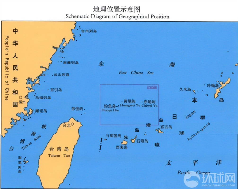
{{Infobox settlement|native_name=钓鱼岛 diào yú dǎo|name=Diaoyu Islands|population_estimate=No residents|area_land_km2=3.91|image_map=钓鱼岛地理位置.jpg}} | {{Message box/Missing Sources}}{{Infobox settlement|native_name=钓鱼岛 diào yú dǎo|name=Diaoyu Islands|population_estimate=No residents|area_land_km2=3.91|image_map=钓鱼岛地理位置.jpg}} | ||
'''Diaoyu | The '''Diaoyu Islands (Chinese: 钓鱼岛)''', known as the '''Senkaku Islands''' in [[Japan]] and the '''Tiaoyutai Islands''' in [[Republic of China|Taiwan]], is a disputed area between [[People's Republic of China|China]] and Japan. The islands are uninhabited and currently administrated by Japan. | ||
== History == | == History == | ||
The archipelago was first recorded in 1403 in the Chinese book "shùn fēng xiāng | The archipelago was first recorded in 1403 in the Chinese book "shùn fēng xiāng sòng (顺风相送)". | ||
In 1561 and 1605, the [[Ming Dynasty]]'s naval defense maps included the islands within the boundaries of China. | In 1561 and 1605, the [[Ming Dynasty]]'s naval defense maps included the islands within the boundaries of China. | ||
| Line 13: | Line 13: | ||
== Controversy between China and Japan == | == Controversy between China and Japan == | ||
On December 25, 1953, Major General David A.D. Ogden of the U.S. Army, Deputy Chief of Civil Affairs of the [[United States of America|U.S.]] National Government of the [[Ryukyu]] Islands, issued "Order No. 27", a bulletin on the "Geographical Boundaries of the Ryukyu Islands". This document was issued by Major General David A.D. Ogden, the Army's "Order No. 27" on "Geographic Boundaries of the Ryukyu Islands". This document unlawfully extended the scope of the U.S. Trusteeship and illegally included the Diaoyu Islands in the U.S. Trusteeship of the [[Ryukyu]] | On December 25, 1953, Major General David A.D. Ogden of the U.S. Army, Deputy Chief of Civil Affairs of the [[United States of America|U.S.]] National Government of the [[Ryukyu]] Islands, issued "Order No. 27", a bulletin on the "Geographical Boundaries of the Ryukyu Islands". This document was issued by Major General David A.D. Ogden, the Army's "Order No. 27" on "Geographic Boundaries of the Ryukyu Islands". This document unlawfully extended the scope of the U.S. Trusteeship and illegally included the Diaoyu Islands in the U.S. Trusteeship of the [[Ryukyu|Ryukyu's]]. | ||
In 1979, Japan built a helicopter field on the Diaoyu Islands, and both | In 1979, Japan built a helicopter field on the Diaoyu Islands, and both mainland China and Taiwan made representations and protests to Japan. | ||
On September 7, 2010, a Chinese fishing boat was attacked by a Japanese warship in the waters near the island, and the crew was detained for 17 days. | On September 7, 2010, a Chinese fishing boat was attacked by a Japanese warship in the waters near the island, and the crew was detained for 17 days. | ||
[[Category:Regions of China]] | |||
[[Category:Regions of Japan]] | |||
[[Category:Territorial disputes]] | |||
Latest revision as of 21:14, 17 November 2024
This article is missing sources. Please do not take all information in this article uncritically, since it may be incorrect. |
钓鱼岛 diào yú dǎo Diaoyu Islands | |
|---|---|
 | |
| Area | |
• Land | 3.91 km² |
| Population | |
• Estimate | No residents |
The Diaoyu Islands (Chinese: 钓鱼岛), known as the Senkaku Islands in Japan and the Tiaoyutai Islands in Taiwan, is a disputed area between China and Japan. The islands are uninhabited and currently administrated by Japan.
History[edit | edit source]
The archipelago was first recorded in 1403 in the Chinese book "shùn fēng xiāng sòng (顺风相送)".
In 1561 and 1605, the Ming Dynasty's naval defense maps included the islands within the boundaries of China.
In 1894, Japan claimed the islands.
On October 25, 1945, Japan returned Taiwan and its annexed islands (including the Diaoyu Islands) to China in a surrender agreement.
Controversy between China and Japan[edit | edit source]
On December 25, 1953, Major General David A.D. Ogden of the U.S. Army, Deputy Chief of Civil Affairs of the U.S. National Government of the Ryukyu Islands, issued "Order No. 27", a bulletin on the "Geographical Boundaries of the Ryukyu Islands". This document was issued by Major General David A.D. Ogden, the Army's "Order No. 27" on "Geographic Boundaries of the Ryukyu Islands". This document unlawfully extended the scope of the U.S. Trusteeship and illegally included the Diaoyu Islands in the U.S. Trusteeship of the Ryukyu's.
In 1979, Japan built a helicopter field on the Diaoyu Islands, and both mainland China and Taiwan made representations and protests to Japan.
On September 7, 2010, a Chinese fishing boat was attacked by a Japanese warship in the waters near the island, and the crew was detained for 17 days.
