More languages
More actions
Tag: Visual edit |
(i put a better map, and fixed its size) |
||
| Line 3: | Line 3: | ||
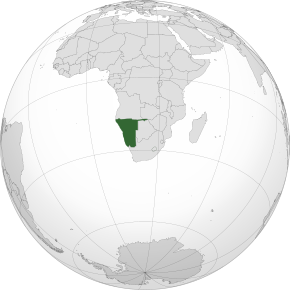
'''Namibia,''' officially the '''Republic of Namibia,''' is a country located in Southern Africa. it borders [[Republic of Angola|Angola]] and [[Republic of Zambia|Zambia]] to the North, [[Botswana]] to the East, and [[Republic of South Africa|South Africa]] to the South. The current ruling and dominant party of Namibia is the [[South West Africa People's Organisation]] (SWAPO), there are other political parties but they have never won elections so far. [[Hage Geingob]] has been president of Namibia since 2015 and has served as prime minister from 1990 since independence up until 2002, then again from 2012 - 2015. | '''Namibia,''' officially the '''Republic of Namibia,''' is a country located in Southern Africa. it borders [[Republic of Angola|Angola]] and [[Republic of Zambia|Zambia]] to the North, [[Botswana]] to the East, and [[Republic of South Africa|South Africa]] to the South. The current ruling and dominant party of Namibia is the [[South West Africa People's Organisation]] (SWAPO), there are other political parties but they have never won elections so far. [[Hage Geingob]] has been president of Namibia since 2015 and has served as prime minister from 1990 since independence up until 2002, then again from 2012 - 2015. | ||
{{Infobox country|name=Republic of Namibia|image_flag=Flag of Namibia.svg|image_coat=Coat of arms of Namibia.svg|capital=Windhoek|government_type=Unitary Multiparty Presidential Parliamentary Republic|motto=Unity, Liberty, Justice|image_map= | {{Infobox country|name=Republic of Namibia|image_flag=Flag of Namibia.svg|image_coat=Coat of arms of Namibia.svg|capital=Windhoek|government_type=Unitary Multiparty Presidential Parliamentary Republic|motto=Unity, Liberty, Justice|image_map=Map_of_Namibia.svg|map_width=290|official_languages=English|recognized_national_languages=Oshikwanyama<br>Oshindonga<br>Rukwangali<br>Otjiherero<br>Rugciriku<br>Thimbukushu<br>Silozi<br>Setswana<br>Khoekhoegowab<br>Ju/’hoan<br>German<br>Afrikaans|ethnic_groups=Ovambo<br>Herero<br>Nama<br>Baster<br>Kavango<br>San<br>Tswana<br>Zambezi<br>White Namibians|demonym=Namibian|legislature=Parliament of Namibia|upper_house=National Council|lower_house=National Assembly|established=1990|area_km2=824,292|population_estimate=2,530,151|population_estimate_year=2021|currency=Namibian Dollar}} | ||
== Colonial Era == | == Colonial Era == | ||
Revision as of 00:56, 19 June 2023
Namibia, officially the Republic of Namibia, is a country located in Southern Africa. it borders Angola and Zambia to the North, Botswana to the East, and South Africa to the South. The current ruling and dominant party of Namibia is the South West Africa People's Organisation (SWAPO), there are other political parties but they have never won elections so far. Hage Geingob has been president of Namibia since 2015 and has served as prime minister from 1990 since independence up until 2002, then again from 2012 - 2015.
| Republic of Namibia | |
|---|---|
Motto: Unity, Liberty, Justice | |
 | |
| Capital | Windhoek |
| Official languages | English |
| Recognized national languages | Oshikwanyama Oshindonga Rukwangali Otjiherero Rugciriku Thimbukushu Silozi Setswana Khoekhoegowab Ju/’hoan German Afrikaans |
| Ethnic groups | Ovambo Herero Nama Baster Kavango San Tswana Zambezi White Namibians |
| Demonym(s) | Namibian |
| Government | Unitary Multiparty Presidential Parliamentary Republic |
| Legislature | Parliament of Namibia |
| National Council | |
| National Assembly | |
| Area | |
• Total | 824,292 km² |
| Population | |
• 2021 estimate | 2,530,151 |
| Currency | Namibian Dollar |
Colonial Era
German Rule
In 1886 the border between Angola and what would be German South West Africa between Germany and Portugal. In 1890 the first German fort was built in Windhoek, and in July 1890, the British apportioned the Caprivi Strip to the Germans. The reason Germany chose Namibia as its “protectorate” was because of the fact that a tobacco merchant from Bremen, Franz Luderitz, bought up coastal land in the area in 1882 which resulted in Germany establishing itself in the country by 1884 and occupied Herero lands. At first the Herero accepted the treaties of protection, but the Nama people did not and resisted. In 1888 the Germans confiscated Herero lands and huge numbers of their cattle, South West Africa was soon turned into a settler colony. in 1890 German soldiers attacked the Nama people and despite the effort of the Herero and the Nama on making a United Front, they were crushed in 1892. German Forces crushed the 1903 Bondelswarts Uprising and the Herero revolt that happened one year later, and then General Lothar von Trotha, the new German commander-in-chief at the time, ordered to exterminate all of the Herero people. Chased by German Troops, the Herero people fled to northern Ovamboland, eastern Bechuanaland, or Botswana. And while that was happening, the Portuguese launched an offensive in northern Ovamboland, and because of that in 1905 the Nama responded with a band of guerrilla fighters. After a year of intense fighting, Hendrik Witbooi (a chief of the Nama people) was killed in action but Jacob Marengo continued to lead the Nama resistance for another two years. In 1907, the death of Marengo brought about the end of the war of resistance, many of the surviving Nama and Herero were imprisoned or sent to labour camps. All the remaining Herero lands were confiscated and they were forbidden to keep cattle. German policy was altered to forcing the survivors into the workforce in order to develop the colony. [1]
From German To South African Rule
When WW1 began broke out in 1914 South Africa agreed to participate in an assault on German South West Africa, but some Afrikaner Nationalists in South Africa opposed this. Led by Generals J.B.M Hertzog and Christiaan Rudolf de Wet, they were against South African participation in the war against Germany and any attack on South West Africa, which they viewed as the colonial territory of a friendly power. The Union Government, however, had military necessity and economic reasons to incorporate the territory into the Union after the war. These conflicting motives and ideals led to the South African Rebellion. With the suppression of the rebellion, General Louis Botha launched South Africa's troops upon the conquest of the German colony and the British navy captured Luderitz Bay in September 1914, cutting off German supplies. South African occupation of the colony started in May 1915 when General Louis Botha, first Prime Minister of the Union of South Africa, ordered 40,000 South African troops into the territory. And since The German troops were heavily outnumbered, they were forced into retreat. The colony surrendered on July 9th, 1915.[1]
Incorporation to South Africa
General JC Smuts, member of the British war cabinet, was unable to persuade the Peace Conference of not wanting to apply the League of Nations Mandate system to Germany's African colonies and wanted South West Africa to be incorporated into South Africa, so in 1920, he and General Louis Botha came to an agreement that South Africa should administer under a Class C Mandate from the League of Nations. The mandate purported to safeguard the rights and interests of the indigenous people. The hopes of the inhabitants of South West Africa for rectify of grievances when the Union Government took over the territory were soon dashed. From 1922 to 1946 the indigenous peoples were allocated from 10.6% to as little as 3.6% of the budget. Even though about 6,000 Germans left the country, grazing lands sequestrated by the German colonial government were not restored. Instead, pastoral chiefdoms and communities were dispossessed and almost half the territory was allocated to some 3,000 White settler ranches that were heavily subsidised. Some of these were given to about three hundred Afrikaners, descendants of Voortrekkers who had previously settled in Angola. Until 1948 the highest authority in the territory was the Administrator of the territory, appointed by the South African Government. Only White settlers were allowed to vote for the Legislative Assembly and local authorities. A resident commissioner and magistrates administered the local inhabitants, issuing directives to chiefs and headmen. Four native commissioners exercised authority in Ovamboland. Black chiefs were treated as government agents who could be replaced or dismissed. Ovamboland was looked on as a labour reserve and very little development was undertaken there.


