More languages
More actions
Verda.Majo (talk | contribs) m (adjusted my wording) Tag: Visual edit |
General-KJ (talk | contribs) m (Added category) Tag: Visual edit |
||
| (One intermediate revision by one other user not shown) | |||
| Line 1: | Line 1: | ||
[[File:Oceania_chart_part_1.png|right|frameless]] | |||
[[File:Oceania chart part 2.png|thumb|Charts depicting political status of countries and territoires in Oceania.]] | |||
'''Oceania''' is a geographical region in the southwestern [[Pacific Ocean|Pacific]] composed of thousands of islands commonly divided into four culturally distinct subregions known as [[Australasia]], [[Melanesia]], [[Micronesia]], and [[Polynesia]]. | '''Oceania''' is a geographical region in the southwestern [[Pacific Ocean|Pacific]] composed of thousands of islands commonly divided into four culturally distinct subregions known as [[Australasia]], [[Melanesia]], [[Micronesia]], and [[Polynesia]]. | ||
According to the [[Asia Society Policy Institute]], "Oceania is increasingly seen as an important geostrategic region among mounting great power competition and is at the forefront of the battle against climate change."<ref>[https://asiasociety.org/policy-institute/oceania “Oceania.”] Asia Society. Accessed 2022-09-15. [https://web.archive.org/web/20220915053137/https://asiasociety.org/policy-institute/oceania Archived] 022-09-15. </ref> | According to the [[Asia Society Policy Institute]], "Oceania is increasingly seen as an important geostrategic region among mounting great power competition and is at the forefront of the battle against climate change."<ref>[https://asiasociety.org/policy-institute/oceania “Oceania.”] Asia Society. Accessed 2022-09-15. [https://web.archive.org/web/20220915053137/https://asiasociety.org/policy-institute/oceania Archived] 022-09-15. </ref> | ||
== Regions == | ==Regions== | ||
Micronesia, which lies north of the equator and west of the International Date Line, includes the [[Mariana Islands]] in the northwest, the [[Caroline Islands]] in the center, the [[Republic of the Marshall Islands|Marshall Islands]] to the west and the islands of [[Republic of Kiribati|Kiribati]] in the southeast. | Micronesia, which lies north of the equator and west of the International Date Line, includes the [[Mariana Islands]] in the northwest, the [[Caroline Islands]] in the center, the [[Republic of the Marshall Islands|Marshall Islands]] to the west and the islands of [[Republic of Kiribati|Kiribati]] in the southeast. | ||
| Line 12: | Line 14: | ||
Australasia comprises [[Australia]], New Zealand, the island of New Guinea, and neighbouring islands in the Pacific Ocean. | Australasia comprises [[Australia]], New Zealand, the island of New Guinea, and neighbouring islands in the Pacific Ocean. | ||
== History == | ==History== | ||
[[File:Migration of Austronesian people across the Pacific.png|thumb|337x337px|A map showing various dates of the migration around regions of Oceania.]] | [[File:Migration of Austronesian people across the Pacific.png|thumb|337x337px|A map showing various dates of the migration around regions of Oceania.]] | ||
There are competing theories regarding the specifics of the prehistory of Oceania and much remains unknown about the region's prehistory. It is commonly believed that the islands of the Pacific were originally migrated to from [[Southeast Asia]] by two different groups of people at widely separated points in time. The first group reached New Guinea and Australia roughly 40,000–60,000 years ago. It would be more than 30,000 years before the descendants of a second wave of Southeast Asian peoples, together with the Melanesians with whom they interacted, began migrating further throughout Oceania.<ref>[https://www.metmuseum.org/toah/ht/02/oc.html “Oceania, 8000–2000 B.C.”] In ''Heilbrunn Timeline of Art History''. New York: The Metropolitan Museum of Art, 2000. [https://web.archive.org/web/20220915114648/https://www.metmuseum.org/toah/ht/02/oc.html Archived] 2022-09-15.</ref> | There are competing theories regarding the specifics of the prehistory of Oceania and much remains unknown about the region's prehistory. It is commonly believed that the islands of the Pacific were originally migrated to from [[Southeast Asia]] by two different groups of people at widely separated points in time. The first group reached New Guinea and Australia roughly 40,000–60,000 years ago. It would be more than 30,000 years before the descendants of a second wave of Southeast Asian peoples, together with the Melanesians with whom they interacted, began migrating further throughout Oceania.<ref>[https://www.metmuseum.org/toah/ht/02/oc.html “Oceania, 8000–2000 B.C.”] In ''Heilbrunn Timeline of Art History''. New York: The Metropolitan Museum of Art, 2000. [https://web.archive.org/web/20220915114648/https://www.metmuseum.org/toah/ht/02/oc.html Archived] 2022-09-15.</ref> | ||
=== European colonization === | ===European colonization=== | ||
Exploration of the region by Europeans began in the 16th century when [[Portuguese Republic|Portuguese]] explorer Ferdinand Magellan landed on the Mariana Islands. [[United Kingdom of Great Britain and Northern Ireland|England]], [[French Republic|France]], [[Federal Republic of Germany|Germany]], and [[Kingdom of Spain|Spain]] became major colonial powers in the region. | Exploration of the region by Europeans began in the 16th century when [[Portuguese Republic|Portuguese]] explorer Ferdinand Magellan landed on the Mariana Islands. [[United Kingdom of Great Britain and Northern Ireland|England]], [[French Republic|France]], [[Federal Republic of Germany|Germany]], and [[Kingdom of Spain|Spain]] became major colonial powers in the region. | ||
=== Second World War === | ===Second World War=== | ||
[[File:A map of the Imperial Powers of the Pacific, 1939-09-01.png|thumb|A map of imperial powers in the Pacific in 1939.]] | [[File:A map of the Imperial Powers of the Pacific, 1939-09-01.png|thumb|A map of imperial powers in the Pacific in 1939.]] | ||
During the [[Second World War]], the Pacific theater was a major battle zone between Japan and the Allied powers. As a result of the military campaigns in Oceania, many territories were given to Allied forces, such as the Solomon Islands (United Kingdom), the Northern Mariana Islands (United States), and the Marshall Islands (United States).<ref>[https://education.nationalgeographic.org/resource/oceania-human-geography “Australia and Oceania: Human Geography | National Geographic Society.”] Nationalgeographic.org. </ref> After the United States acquired Japanese colonies in the northern Pacific, it established a major military facility in the Marshall Islands and expanded its bases in [[Guam]] and Hawaii.<ref>[https://www.culturalsurvival.org/publications/cultural-survival-quarterly/oceania-islands-land-people “Oceania: Islands, Land, People.”] Culturalsurvival.org. [https://web.archive.org/web/20220324015504/https://www.culturalsurvival.org/publications/cultural-survival-quarterly/oceania-islands-land-people Archived] 2022-03-24.</ref> | During the [[Second World War]], the Pacific theater was a major battle zone between Japan and the Allied powers. As a result of the military campaigns in Oceania, many territories were given to Allied forces, such as the Solomon Islands (United Kingdom), the Northern Mariana Islands (United States), and the Marshall Islands (United States).<ref>[https://education.nationalgeographic.org/resource/oceania-human-geography “Australia and Oceania: Human Geography | National Geographic Society.”] Nationalgeographic.org. </ref> After the United States acquired Japanese colonies in the northern Pacific, it established a major military facility in the Marshall Islands and expanded its bases in [[Guam]] and Hawaii.<ref>[https://www.culturalsurvival.org/publications/cultural-survival-quarterly/oceania-islands-land-people “Oceania: Islands, Land, People.”] Culturalsurvival.org. [https://web.archive.org/web/20220324015504/https://www.culturalsurvival.org/publications/cultural-survival-quarterly/oceania-islands-land-people Archived] 2022-03-24.</ref> | ||
| Line 25: | Line 27: | ||
U.S. general [[Douglas MacArthur]], who played a prominent role in the Pacific theater during the Second World War as well as leading the [[United Nations Command]] during the [[Korean War]], spoke of the strategic importance of the Pacific region from the US imperialist point of view in a 1951 speech, referring to the Pacific as a "vast moat to protect us as long as we held it" saying, "it acts as a protective shield for all of the [[Americas]] and all free lands of the Pacific Ocean area. We control it to the shores of [[Asia]] by a chain of islands extending in an arc from the [[Aleutians]] to the Marianas held by us and our free allies. From this island chain we can dominate with sea and air power every Asiatic port from [[Vladivostok]] to [[Republic of Singapore|Singapore]] [...] and prevent any hostile movement into the Pacific." In this speech, he emphasized that if there were holes in this chain of dominance, particularly the loss of Japan or the Philippines, this "might well force our western frontier back to the coast of [[California]], [[Oregon]] and [[State of Washington|Washington]]." In MacArthur's view, US dominance of the Pacific islands would be key in preventing what he believed would be the inevitable "lust for expansion" of communist [[People's Republic of China|China]], saying that "With naval and air supremacy and modest ground elements to defend bases, any major attack from continental Asia toward us or our friends in the Pacific would be doomed to failure" as long as the US continued to maintain a line of "defense" throughout the Pacific islands.<ref>MacArthur, Douglas. [https://www.americanrhetoric.com/speeches/douglasmacarthurfarewelladdress.htm “American Rhetoric: General Douglas MacArthur -- Farewell Address to Congress.”] Americanrhetoric.com. [https://web.archive.org/web/20221104024041/https://www.americanrhetoric.com/speeches/douglasmacarthurfarewelladdress.htm Archived] 2022-11-04.</ref> | U.S. general [[Douglas MacArthur]], who played a prominent role in the Pacific theater during the Second World War as well as leading the [[United Nations Command]] during the [[Korean War]], spoke of the strategic importance of the Pacific region from the US imperialist point of view in a 1951 speech, referring to the Pacific as a "vast moat to protect us as long as we held it" saying, "it acts as a protective shield for all of the [[Americas]] and all free lands of the Pacific Ocean area. We control it to the shores of [[Asia]] by a chain of islands extending in an arc from the [[Aleutians]] to the Marianas held by us and our free allies. From this island chain we can dominate with sea and air power every Asiatic port from [[Vladivostok]] to [[Republic of Singapore|Singapore]] [...] and prevent any hostile movement into the Pacific." In this speech, he emphasized that if there were holes in this chain of dominance, particularly the loss of Japan or the Philippines, this "might well force our western frontier back to the coast of [[California]], [[Oregon]] and [[State of Washington|Washington]]." In MacArthur's view, US dominance of the Pacific islands would be key in preventing what he believed would be the inevitable "lust for expansion" of communist [[People's Republic of China|China]], saying that "With naval and air supremacy and modest ground elements to defend bases, any major attack from continental Asia toward us or our friends in the Pacific would be doomed to failure" as long as the US continued to maintain a line of "defense" throughout the Pacific islands.<ref>MacArthur, Douglas. [https://www.americanrhetoric.com/speeches/douglasmacarthurfarewelladdress.htm “American Rhetoric: General Douglas MacArthur -- Farewell Address to Congress.”] Americanrhetoric.com. [https://web.archive.org/web/20221104024041/https://www.americanrhetoric.com/speeches/douglasmacarthurfarewelladdress.htm Archived] 2022-11-04.</ref> | ||
=== Nuclear testing === | ===Nuclear testing=== | ||
According to a Monthly Review Online article, the US conducted 105 [[Nuclear weapons|nuclear]] tests in the Pacific, mainly in the Marshall islands, between 1946 and 1962, as part of its program to develop thermonuclear bombs. Operational weapons were sometimes tested, including a submarine-launched war head. One test in 1952 completely vaporised the island of Eluglab. In 1954, a thermonuclear bomb tested on Bikini atoll exploded with force of 15 megatons – over 1,000 times bigger than the bomb dropped on [[Hiroshima]]. The radioactive cloud engulfed a Japanese fishing boat about 80 miles away in a white powder that poisoned the crew. One died from the exposure seven months later and 15 more in following years. The radioactivity affected the drinking water and food and in 2005, the US National Cancer Institute reported that the risk of contracting cancer for those exposed to the fallout was over one in three.<ref name=":0">Toohey, Brian. [https://mronline.org/2022/06/25/the-united-states-the-pacific-bully/ “The United States- the Pacific Bully”] MR Online. June 25, 2022. [https://web.archive.org/web/20220915054737/https://mronline.org/2022/06/25/the-united-states-the-pacific-bully/ Archived] 2022-09-15. | According to a Monthly Review Online article, the US conducted 105 [[Nuclear weapons|nuclear]] tests in the Pacific, mainly in the Marshall islands, between 1946 and 1962, as part of its program to develop thermonuclear bombs. Operational weapons were sometimes tested, including a submarine-launched war head. One test in 1952 completely vaporised the island of Eluglab. In 1954, a thermonuclear bomb tested on Bikini atoll exploded with force of 15 megatons – over 1,000 times bigger than the bomb dropped on [[Hiroshima]]. The radioactive cloud engulfed a Japanese fishing boat about 80 miles away in a white powder that poisoned the crew. One died from the exposure seven months later and 15 more in following years. The radioactivity affected the drinking water and food and in 2005, the US National Cancer Institute reported that the risk of contracting cancer for those exposed to the fallout was over one in three.<ref name=":0">Toohey, Brian. [https://mronline.org/2022/06/25/the-united-states-the-pacific-bully/ “The United States- the Pacific Bully”] MR Online. June 25, 2022. [https://web.archive.org/web/20220915054737/https://mronline.org/2022/06/25/the-united-states-the-pacific-bully/ Archived] 2022-09-15. | ||
| Line 36: | Line 38: | ||
In 2014, the Marshall Islands attempted to sue the US and eight other nuclear armed nations, for failing to move towards nuclear disarmament as required by the Nuclear Non-Proliferation Treaty. A US Court dismissed the suit in 2017.<ref name=":0" /> | In 2014, the Marshall Islands attempted to sue the US and eight other nuclear armed nations, for failing to move towards nuclear disarmament as required by the Nuclear Non-Proliferation Treaty. A US Court dismissed the suit in 2017.<ref name=":0" /> | ||
== References == | ==References== | ||
<references /> | <references /> | ||
[[Category:Continents]] | |||
Latest revision as of 15:56, 6 November 2024
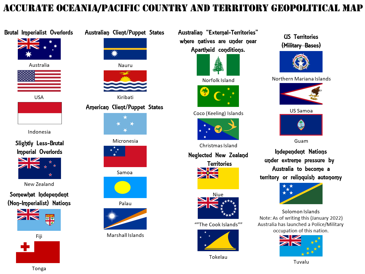
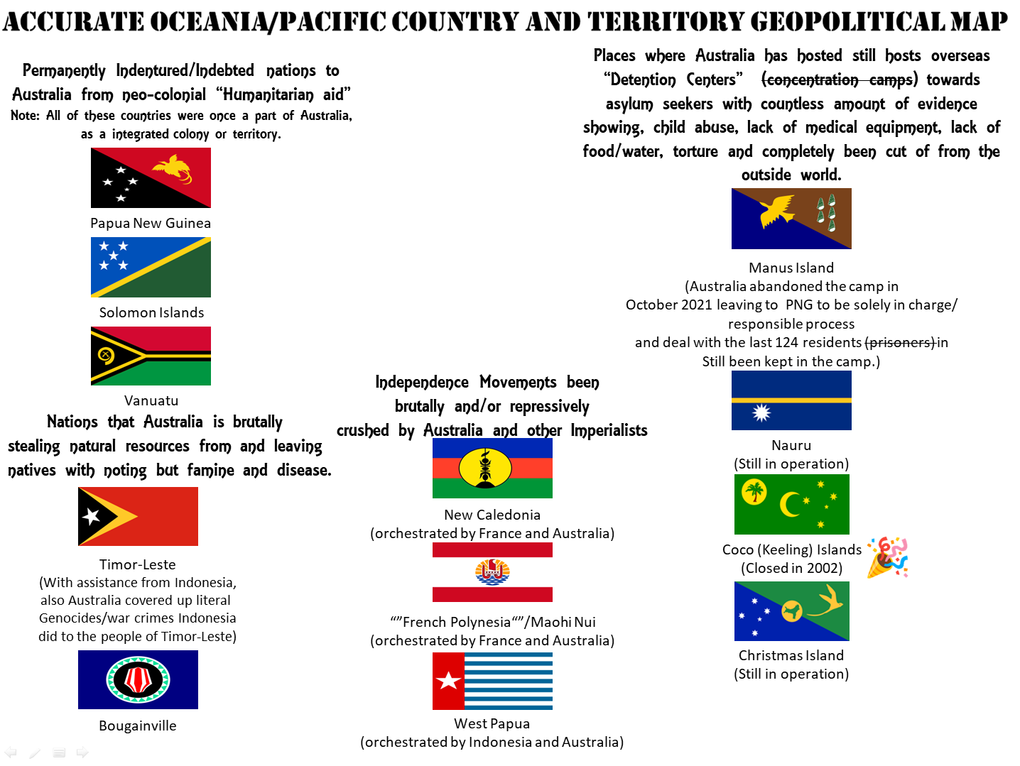
Oceania is a geographical region in the southwestern Pacific composed of thousands of islands commonly divided into four culturally distinct subregions known as Australasia, Melanesia, Micronesia, and Polynesia.
According to the Asia Society Policy Institute, "Oceania is increasingly seen as an important geostrategic region among mounting great power competition and is at the forefront of the battle against climate change."[1]
Regions[edit | edit source]
Micronesia, which lies north of the equator and west of the International Date Line, includes the Mariana Islands in the northwest, the Caroline Islands in the center, the Marshall Islands to the west and the islands of Kiribati in the southeast.
Melanesia, to the southwest, includes New Guinea, the world's second largest island after Greenland and by far the largest of the Pacific islands. The other main Melanesian groups from north to south are the Maluku Islands Archipelago, the Bismarck Archipelago, the Solomon Islands archipelago, Santa Cruz, Vanuatu, Fiji and New Caledonia.
Polynesia, stretching from Hawaii in the north to New Zealand in the south, also encompasses Tuvalu, Tokelau, Samoa, Tonga and the Kermadec Islands to the west, the Cook Islands, Society Islands and Austral Islands in the center, and the Marquesas Islands, Tuamotu, Mangareva Islands, and Easter Island to the east.
Australasia comprises Australia, New Zealand, the island of New Guinea, and neighbouring islands in the Pacific Ocean.
History[edit | edit source]
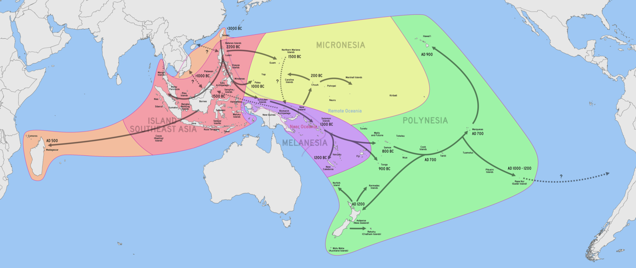
There are competing theories regarding the specifics of the prehistory of Oceania and much remains unknown about the region's prehistory. It is commonly believed that the islands of the Pacific were originally migrated to from Southeast Asia by two different groups of people at widely separated points in time. The first group reached New Guinea and Australia roughly 40,000–60,000 years ago. It would be more than 30,000 years before the descendants of a second wave of Southeast Asian peoples, together with the Melanesians with whom they interacted, began migrating further throughout Oceania.[2]
European colonization[edit | edit source]
Exploration of the region by Europeans began in the 16th century when Portuguese explorer Ferdinand Magellan landed on the Mariana Islands. England, France, Germany, and Spain became major colonial powers in the region.
Second World War[edit | edit source]
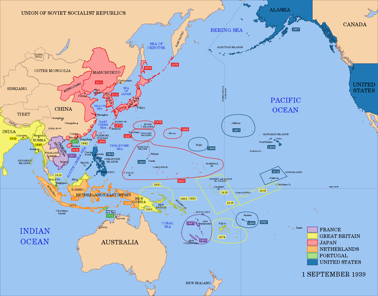
During the Second World War, the Pacific theater was a major battle zone between Japan and the Allied powers. As a result of the military campaigns in Oceania, many territories were given to Allied forces, such as the Solomon Islands (United Kingdom), the Northern Mariana Islands (United States), and the Marshall Islands (United States).[3] After the United States acquired Japanese colonies in the northern Pacific, it established a major military facility in the Marshall Islands and expanded its bases in Guam and Hawaii.[4]
U.S. general Douglas MacArthur, who played a prominent role in the Pacific theater during the Second World War as well as leading the United Nations Command during the Korean War, spoke of the strategic importance of the Pacific region from the US imperialist point of view in a 1951 speech, referring to the Pacific as a "vast moat to protect us as long as we held it" saying, "it acts as a protective shield for all of the Americas and all free lands of the Pacific Ocean area. We control it to the shores of Asia by a chain of islands extending in an arc from the Aleutians to the Marianas held by us and our free allies. From this island chain we can dominate with sea and air power every Asiatic port from Vladivostok to Singapore [...] and prevent any hostile movement into the Pacific." In this speech, he emphasized that if there were holes in this chain of dominance, particularly the loss of Japan or the Philippines, this "might well force our western frontier back to the coast of California, Oregon and Washington." In MacArthur's view, US dominance of the Pacific islands would be key in preventing what he believed would be the inevitable "lust for expansion" of communist China, saying that "With naval and air supremacy and modest ground elements to defend bases, any major attack from continental Asia toward us or our friends in the Pacific would be doomed to failure" as long as the US continued to maintain a line of "defense" throughout the Pacific islands.[5]
Nuclear testing[edit | edit source]
According to a Monthly Review Online article, the US conducted 105 nuclear tests in the Pacific, mainly in the Marshall islands, between 1946 and 1962, as part of its program to develop thermonuclear bombs. Operational weapons were sometimes tested, including a submarine-launched war head. One test in 1952 completely vaporised the island of Eluglab. In 1954, a thermonuclear bomb tested on Bikini atoll exploded with force of 15 megatons – over 1,000 times bigger than the bomb dropped on Hiroshima. The radioactive cloud engulfed a Japanese fishing boat about 80 miles away in a white powder that poisoned the crew. One died from the exposure seven months later and 15 more in following years. The radioactivity affected the drinking water and food and in 2005, the US National Cancer Institute reported that the risk of contracting cancer for those exposed to the fallout was over one in three.[6]
Britain tested 40 thermonuclear bombs on an islands in the Kiribati group between 1957 and 1962. Troops from Britain , Fiji (then a British colony), and New Zealand worked on the tests. Many were harmed by radiation and other causes. The author of the article in Monthly Review noted, "As usual, the locals were treated badly and their water and lands polluted."[6]
France conducted 41 atmospheric nuclear tests between 1966 and 1974 in French Polynesia. It then conducted 140 underground, primarily of thermonuclear bombs, until 1996. One of the islands used was subject to cracking. In an act of state terrorism, French secret service frogman killed a photographer when they bombed a Green Peace protest ship in Auckland harbour on its way to the French nuclear testing area.
In 2014, the Marshall Islands attempted to sue the US and eight other nuclear armed nations, for failing to move towards nuclear disarmament as required by the Nuclear Non-Proliferation Treaty. A US Court dismissed the suit in 2017.[6]
References[edit | edit source]
- ↑ “Oceania.” Asia Society. Accessed 2022-09-15. Archived 022-09-15.
- ↑ “Oceania, 8000–2000 B.C.” In Heilbrunn Timeline of Art History. New York: The Metropolitan Museum of Art, 2000. Archived 2022-09-15.
- ↑ “Australia and Oceania: Human Geography | National Geographic Society.” Nationalgeographic.org.
- ↑ “Oceania: Islands, Land, People.” Culturalsurvival.org. Archived 2022-03-24.
- ↑ MacArthur, Douglas. “American Rhetoric: General Douglas MacArthur -- Farewell Address to Congress.” Americanrhetoric.com. Archived 2022-11-04.
- ↑ 6.0 6.1 6.2 Toohey, Brian. “The United States- the Pacific Bully” MR Online. June 25, 2022. Archived 2022-09-15.
